Modern road and infrastructure projects demand highly accurate digital documentation. Traditional 2D drawings are no longer sufficient for complex corridors, multi-level flyovers, and utility-dense urban highways.
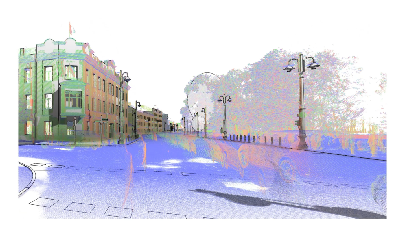
At TerraModus, we successfully transformed a scanned road infrastructure project into a detailed 3D Revit model using high-density LiDAR data.
This project demonstrates how reality capture and BIM integration streamline infrastructure planning, renovation, and asset management.
Project Objective
The goal was to:
✔ Capture high-accuracy spatial data of an existing road corridor
✔ Digitize the full infrastructure environment
✔ Develop an accurate BIM model in Autodesk Revit
✔ Create a structured digital record for engineering and planning
The project included:
- Road carriageways
- Medians & shoulders
- Drainage systems
- Roadside infrastructure
- Bridges/underpasses (if applicable)
- Surrounding terrain
Step 1: LiDAR Scanning of the Road Corridor
Using advanced terrestrial and/or mobile LiDAR systems, we captured millions of data points across the entire corridor.
The scanning process delivered:
- High-density point cloud data
- Accurate horizontal & vertical geometry
- Detailed terrain profiles
- Existing structure documentation
LiDAR enabled rapid data collection with minimal traffic disruption.
Step 2: Point Cloud Processing & Alignment
Once field data was captured, we:
- Cleaned and filtered the raw point cloud
- Removed noise and irrelevant data
- Georeferenced the dataset
- Established control accuracy
This stage ensured the dataset was engineering-grade and ready for BIM modeling.
Step 3: Road Infrastructure Modeling in Revit
The processed point cloud was imported into Autodesk Revit to create a structured 3D model.
In Revit, we developed:
✔ Accurate road geometry
✔ Lane widths and slopes
✔ Pavement layers
✔ Drainage channels
✔ Structural components
✔ Adjacent terrain surfaces
The result was a parametric, editable BIM model ready for engineering use.
Why LiDAR + Revit Is Powerful for Road Infrastructure
This workflow offers significant advantages over traditional documentation methods:
🎯 High Accuracy
Captures real-world geometry with millimeter-to-centimeter precision.
⏱ Faster Project Delivery
Rapid scanning reduces time spent in the field.
📐 BIM-Ready Infrastructure Data
Structured models improve coordination between design and execution teams.
🔄 Retrofit & Expansion Planning
Perfect for road widening, rehabilitation, and infrastructure upgrades.
Applications of This Workflow
This approach is ideal for:
- Highway corridor documentation
- Metro and elevated road integration
- Urban road redesign
- Road widening projects
- Bridge and flyover renovation
- Smart city infrastructure planning
It also supports:
- Digital twin development
- Asset lifecycle management
- Utility conflict analysis
- Volume and alignment verification
Deliverables Provided
For this project, deliverables included:
✔ Clean, georeferenced point cloud
✔ Revit-based 3D BIM model
✔ CAD-compatible exports
✔ Elevation & cross-section data
✔ Terrain models
All outputs were structured for engineering and long-term infrastructure management.
Transforming Physical Roads into Digital Assets
As infrastructure becomes more data-driven, digital modeling is essential for:
- Accurate planning
- Reduced construction risk
- Improved maintenance
- Long-term asset tracking
By combining LiDAR scanning with BIM modeling in Revit, TerraModus converts complex road infrastructure into precise, actionable digital environments.
Planning a Road or Infrastructure Digitization Project?
If you’re working on:
- Highway upgrades
- Urban road redevelopment
- Infrastructure modernization
- Smart city planning
- Corridor documentation
Our team delivers advanced LiDAR scanning and Revit-based 3D modeling solutions tailored to large-scale infrastructure projects.